
Sri Lanka is a country that is rich in culture and historical significance. From Jaffna to Anuradhapura to Galle, and everything in between, the story of Sri Lanka is ever present in the monuments constructed by the great kings of old. But, with time, everything decays so how does one conserve this heritage? Well, this is where a technology called LIDAR comes into play.
What is LIDAR?
LIDAR or Light Detection and Ranging is a method of surveying that measures distance to a target by illuminating that target with a pulsed laser light and measuring the reflected pulses with a sensor. Using these light pulses coupled with other data recorded by an aircraft, it is possible to generate a precise, 3D model of an object or location.
A LIDAR instrument typically consists of a laser, a scanner, and a specialized GPS receiver. Vehicles such as Airplanes and helicopters are by far the most common tools used with the latest addition being drones, for acquiring LIDAR data over large areas.
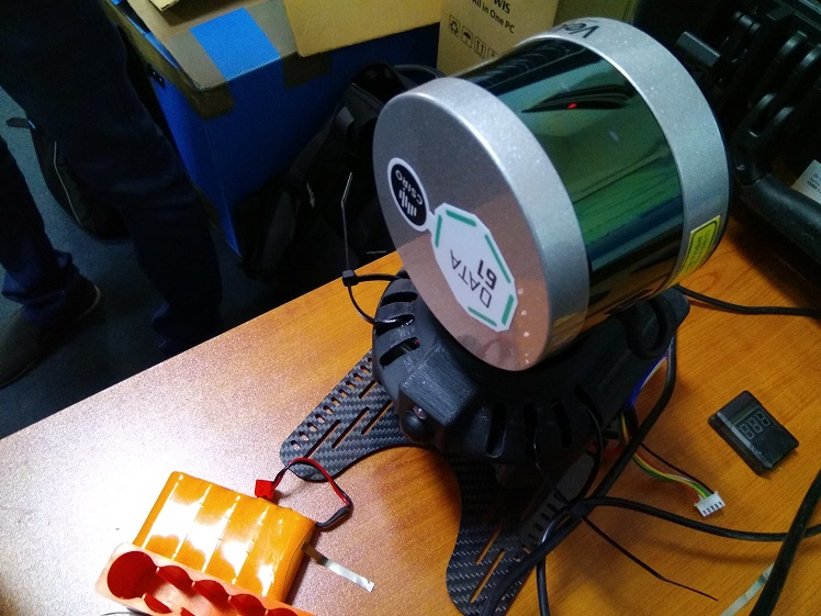
Image credits: RCS2 Technologies
The Commonwealth Scientific and Industrial Research Organization better known as CSIRO which is located in Australia, has proposed a pilot project to the Department of Archaeology that involves this LIDAR technology to 3D map archaeological heritage sites in Sri Lanka with the intention of aiding archaeology in preserving these historical monuments.
Called “LIDAR Based 3D Mapping for Nondestructive Heritage Conservation”, the project also involves the University of Moratuwa, and RCS2 Technologies as their partners. In case you were wondering, RCS2 Technologies is a company in Sri Lanka that wants to make 3D printing simple and make the world smarter with their own brand of Sri Lankan 3D Printers: Thrimána.
What does this LIDAR Project aim to do?
Simply put, by using LIDAR instruments, the project team, headed by Dr. Navinda Kottege, Senior Research Scientist, CSIRO, will scan all historical monuments and then create 3D models. This is done by using a technology called “Hovermap”. This is a technology developed by CSIRO that makes use of CSIRO’s proprietary Simultaneous Localization and Mapping AKA SLAM, to to generate 3D point clouds. It is also done without the means of a GPS and also allows a low cost high-resolution UAV-based LIDAR mapping system that can be used both indoors and outdoors. The captured data is then processed with CSIRO’s SLAM software to produce a 3D point cloud. This is viewed via Cloudcompare, which is a free software that is a visualization tool used to view the point cloud.
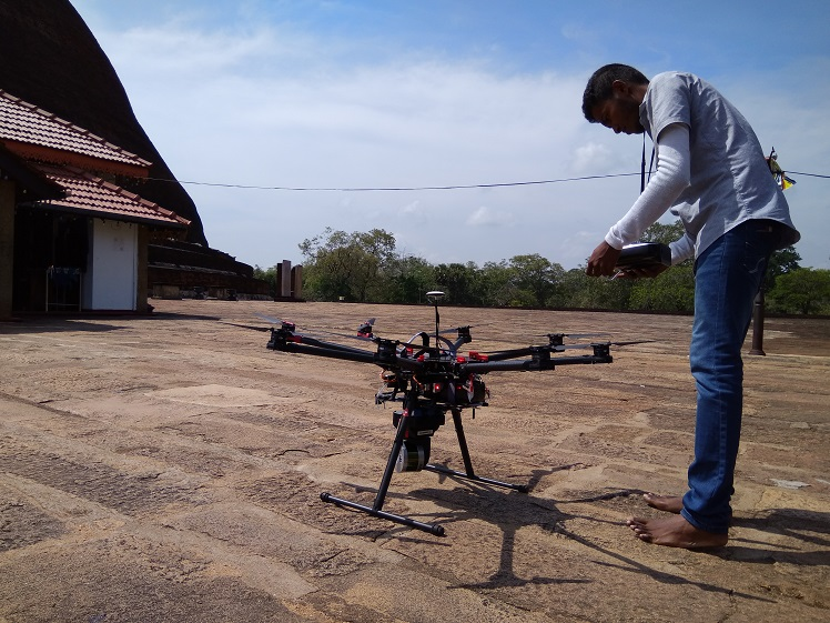
Image credits: RCS2 Technologie
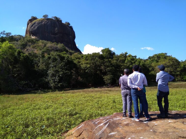
The team kicked off the project on the 2nd of May 2017 all the way to the 7th of May 2017. During this period, the team visited sites such as the Jethawanarama Sthupaya, Kuttam Pokuna, Sigiriya, and Polonnaruwa. They attached the LIDAR device to a drone and proceeded to record the architectural data of the location by flying the drone around the location and capturing images of it. The captured data was then fed into CloudCompare, which is an open-source 3D point cloud processing software.
Why would they do this?
Quite simply, to preserve our cultural heritage without damaging it. For example, if one of these sites needs to be renovated or repaired after an incident, the archaeologists can go over the 3D model of the location to locate the exact problem and then see how it can be repaired. Using the LIDAR, you can calculate the surface of an object or building and even calculate how many bricks and stones are in a section of a structure. The measurement scale provides an on-point scale that can be used to measure distances with almost 100% accuracy.
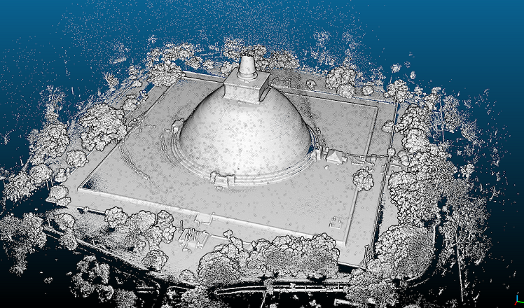
Image credits: RCS2 Technologies
In addition, apart from preserving our cultural heritage, the use of this LIDAR technology can also be used for commercial purposes. For example, one of the advantages of this project can be having a 3d printed model of Sigiriya that you can carry with you and show off for educational purposes or even to showcase at foreign conferences to show off our heritage. If detailed enough, it can even be sold as a consumer product. After all, it would be pretty cool to have a 3D-printed accurate scale model of Sigiriya on your table and it certainly would be a good conversation starter.
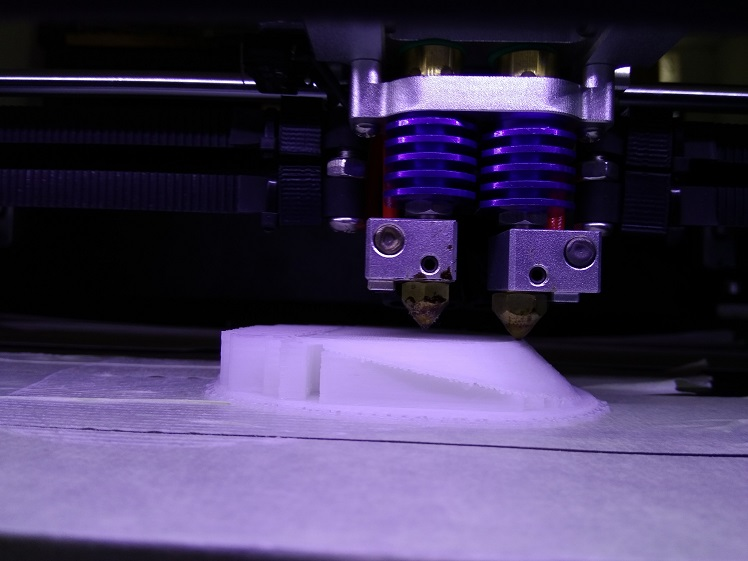
Currently, RSC2 Technologies is sponsoring the project, and The 3D software models of the monuments were successfully created they were also printed in 3D and tested by RCS2 technologies. Furthermore, research is underway to develop a software system to enable archaeologists to reconstruct monuments in a virtual environment before the actual preservation of the monuments is carried out. The case study is the ancient city of Mudukondapola, Nikasalanuwara, Kandemedagama. The project is further extendable and the team plans to propose a large-scale 3D mapping, post-processing, and 3D printing exercise for Sri Lankan heritage sites.
We commend CSIRO, RCS2 Technologies, and the University of Moratuwa for lending their support to help safeguard our historical monuments and we wish them all the best in all their future endeavors. As always, we will be ready to bring you any news regarding further developments with the project as and when it happens.

Nice project & glad to note that LIDAR is used in SL. This is the good side of technology. Hope MOD is carefully monitoring these developments.
Thank you for updating the article Mahesh.
Hi; I am a lecturer of Architecture at the UNiversity of Greenwich in London and would like to get in touch with the projct team – would you be able to pass on some contact details?
Thanks in advance
Hi,
You could probably reach out to them via rajitha [@] rcstotech.com